As another weekend approaches, a snowstorm is looming over the tri-state area, promising a wintry mix of snow, rain, and icy conditions. While Valentine’s Day kicks off with sunny but chilly weather, gusty winds will make it feel even colder, with temperatures plunging to the teens and 20s throughout the day. However, the skies will stay dry through early Saturday, setting the stage for the impending winter weather advisories.
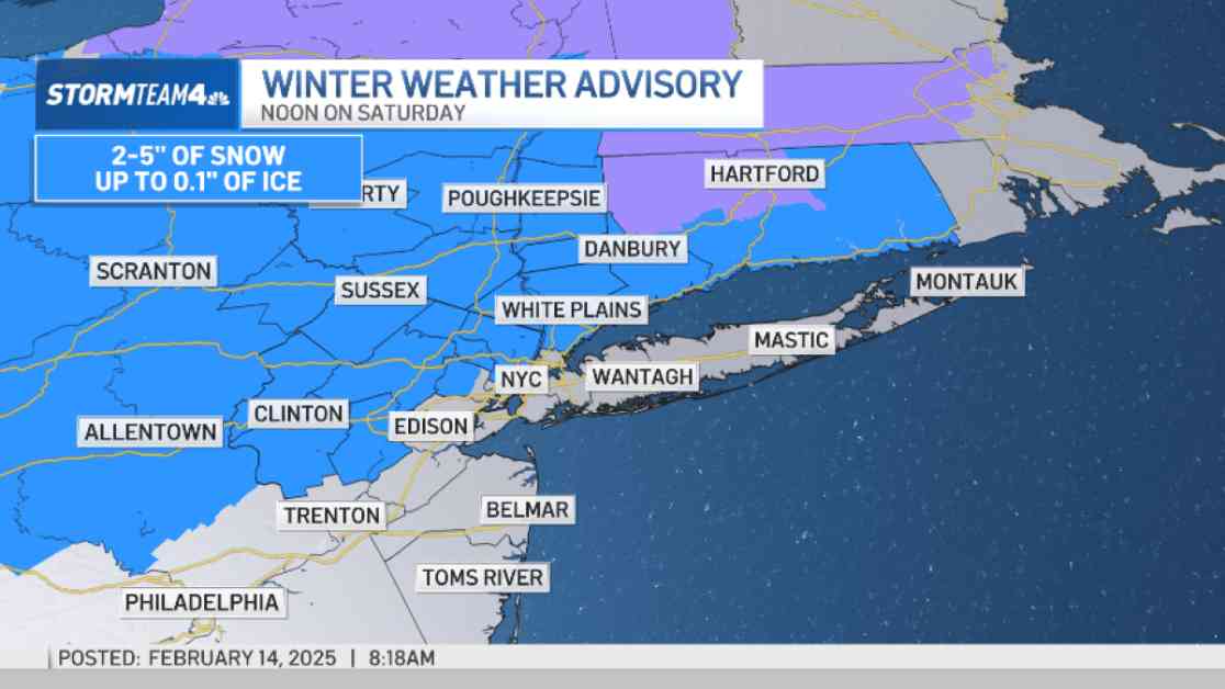
Winter Weather Advisories are set to go into effect at noon on Saturday for most of central/northern New Jersey, the Hudson Valley, and Fairfield County. Surprisingly, New York City, southern New Jersey, and Long Island are currently excluded from any advisory as of 8 a.m. on Friday, leaving residents in these areas on the edge of their seats.
### Snowy Start and Rainy Transformation
The burning question on everyone’s mind is, “When will the snow start this weekend?” Brace yourselves, as snow is expected to blanket the region by noon on Saturday. After several hours of snowfall, a warm front will push northward, causing the snow to transition into an icy mix and eventually rain. In New York City, the snow is forecasted to shift to rain by late dinner time, offering residents a reprieve from the blanket of white.
Compared to areas situated north of the city, the snowfall in New York City will begin later and conclude earlier over the weekend. Consequently, this pattern will result in lower snow totals and a higher likelihood of rain, sparing city dwellers from the full force of the storm.
### Hudson Valley’s Weather Woes
The Hudson Valley emerges as a focal point for weather watchers, with the region poised to bear the brunt of the storm’s impact. Anticipate several hours of snow and ice in the Hudson Valley, especially around the I-84 corridor, where ice accretion of up to a couple of tenths of an inch is possible. The snow is projected to commence in the Hudson Valley by mid-morning on Saturday, persisting throughout the day before transitioning into a messy wintry mix of sleet, rain, and ice overnight into Sunday. Freezing rain poses a significant risk in the Hudson Valley on Sunday, warranting caution and preparation.
### Snow to Rain: The Ultimate Transition
A pivotal moment in the weather narrative is the transition from snow to rain, which is expected to occur late Saturday night or early Sunday morning across the entire tri-state area. The rain is forecasted to persist through most of Sunday, with a slight chance of thunder as the front clears later in the afternoon. This meteorological dance between snow and rain underscores the unpredictable nature of winter storms and the resilience of residents as they navigate the ever-changing forecast.
### Snow Totals and Temperature Tumult
Curious minds wonder, “How much snow will the tri-state get?” This weekend’s storm follows a predictable pattern where areas further north are likely to experience greater snow accumulation due to colder temperatures and prolonged snowfall, while regions further south will witness a swifter transition to rain. As the storm wanes, much colder air is set to descend upon the tri-state area, plunging temperatures back down to the teens, setting the stage for a frigid start to the new week.
As we gear up for a weekend of snow, rain, and icy conditions, residents across the tri-state area are advised to stay informed, exercise caution, and prepare for the unpredictable weather that lies ahead. Embrace the wintry mix with fortitude and resilience, knowing that brighter days are on the horizon, even amidst the snowflakes and raindrops.


